This is a post that I’ve wanted to make for a long time. In fact, my obsession with the details of this story was the cause of my own procrastination from writing it. Much like Dune, it requires a lot of exposition and character introductions. In many ways, the story of Michigan’s statehood is the story of America’s first half-century. In order to properly cover all the finer points of the conflict, I have decided to break down my post into three parts. In this segment, I will focus on the background to Michigan’s and Ohio’s claims to the Toledo Strip. What made Toledo worth fighting a war over?
“Never in the course of my life have I known a controversy of which all the right was so clearly on one side, and all the power so overwhelmingly on the other; never a case where the temptation was so intense to take the strongest side, and the duty of taking the weakest so thankless.”
Representative John Quincy Adams, 1836

Michigan and Ohio hate each other. Today, their hatred is mostly manifest in the annual college football matchup between the University of Michigan Wolverines and the Ohio State University Buckeyes. It is considered one of the fiercest rivalries in all sports. But their animosity goes back much further than the existence of the football teams, or even the universities themselves. In the early-Nineteenth Century, Ohioans considered Michiganders to be wild and ferocious, likening them to “wolverines.” Michiganders believed that Ohioans were bullies who abused their political power to dominate their emerging state. The root of the conflict was a dispute over the Toledo Strip – a 468 square-mile stretch along their shared border. It was five miles wide at the Indiana border, and eight miles wide at Lake Erie. Both states made claims to the Toledo Strip in the early-1800s. The issue was largely overlooked, however, until Michigan applied for statehood in the 1830s. When the federal government failed to properly intervene, Michiganders and Ohioans resorted to violence to assert their claim.
Midwest Expansion
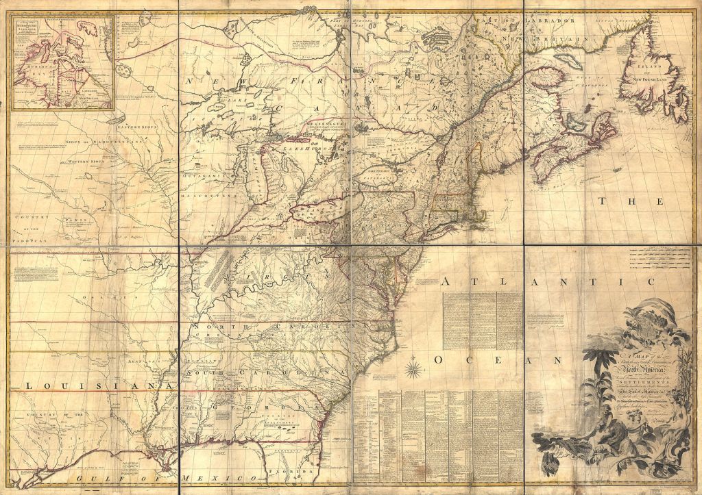

The Mitchell Map of 1755 was the definitive map of the American colonies for the British government. Virginia physician John Mitchell detailed not only the Atlantic coast, but the (mid)west, as well. Unfortunately, due to the technological constraints of the time, there were some inaccuracies. The misshapen Great Lakes are the easiest to identify. According to Mitchell’s depiction, Michigan should be known as the “claw” state, rather than the mitten state. More importantly, his map also placed the southern tip of Lake Michigan too far north, relative to the position of Lake Erie. But, hey, no settlers lived there yet, so no big deal, right?
In the mid-1700s, the original thirteen colonies used the vague language of their charters and treaties to grant themselves vast amounts of territory west of the Appalachian Mountains. Virginia once claimed everything northwest of the Ohio River. Connecticut asserted that it restarted west of New York. It was chaos. After the Revolution, however, Americans started seeing these lands as a shared benefit and a shared responsibility (the preexistence of Native Americans on these lands notwithstanding). The original states finally gave up their western claims throughout the 1780s.
The Northwest Ordinance of 1787 outlined America’s plans for expansion in what is now considered the Midwest. This act of the Continental Congress (still under the Articles of Confederation) set the conditions by which a region could become a territory, and eventually a state. A territory received a governor, a secretary, and three judges appointed by Congress. Once it reached a population of 5,000 (free adult males), it could form a legislative assembly and designate a delegate to Congress. Lastly, a territory with over 60,000 residents earned the right to form a state constitution and a state government. Notably, the Northwest Ordinance also prohibited slavery, reaffirmed the freedom of religion, and advocated for public spending on education. The most important aspect of the Ordinance, however, was the autonomy it granted new states. Additions to the United States would not be inferior to the original thirteen, but rather, equal entities under the federal government. This meant that any border alterations between states required mutual consent. The United States’ break from the European model of colonization was arguably as important to the growth of the new nation as the Declaration of Independence and the Constitution – though the adoption of the latter document prompted the additional requirement that new states be officially admitted by Congress.
Despite the egalitarian status offered to the potential new states, politicians at the time feared that the admission of too many states would weaken the power of the originals. The Northwest Ordinance stipulated that its land would be used to create “not less than three nor more than five states,” based on a plan first proposed by Thomas Jefferson. Additionally, it specified that the boundary between the northern and southern states in the region would be marked by “an east and west line drawn through the southerly bend of extreme of Lake Michigan.” This proved to be the most controversial piece of the Ordinance. Unfortunately, the basis of the boundary was the Mitchell Map. While more accurate maps had been produced since 1755, by virtue of its official status, the Mitchell Map remained Congress’ de facto depiction of the continent. The authors of the Northwest Ordinance most likely intended to maximize lake access for all of the new states. From their understanding, the entirety of Lake Erie’s west coast lay farther south than Lake Michigan, placing it in the soon-to-be-state of Ohio. In reality, they had cut off Ohio from one of its most geographically important shipping routes.

The text of the Northwest Ordinance, inscribed of the University of Michigan’s Angell Hall3
The States Take Shape
In 1803, Ohio became the first state to be admitted from the Northwest Territories. Their newfound representation in the federal government gave Ohioans considerable influence over their neighbors. Local settlers had become aware of the discrepancies in the Mitchell Map and were concerned that their true northern border with Michigan Territory would restrict their access to Lake Erie. Specifically, they wanted to control Maumee Bay, the entrance-point of the Maumee River. Running southwest across Ohio to Fort Wayne, Indiana, the river was sure to be a vital shipping route for the growing state. To ensure that their border was drawn north of the bay, the delegates at Ohio’s constitutional convention added a proviso stating, “…should [the border] not be found to intersect Lake Erie, or to intersect it east of the mouth of the Maumee River, then with the assent of Congress, the boundary should be a straight line running from the southernly extreme of the lake to the most northerly cape of Maumee Bay.” The proviso was Ohio’s first official claim to the region, but it required Congressional approval. When members of Congress admitted Ohio as a state, Ohioans conveniently interpreted their silence on the proviso as consent.
Ohio wasn’t the only state to ignore the border outlined in the Northwest Ordinance. When Indiana became a state in 1816, it placed its border ten miles north of the line to gain more access to Lake Michigan. Similarly, two years later, Illinois claimed an extra sixty miles to include Fort Dearborn – now known as Chicago. Since the land in question was mostly unsettled at the time, these claims went uncontested.
In 1817, in order to assert Ohio’s claims to Maumee Bay, US Surveyor General Edward Tiffin (formerly Ohio’s first governor) ordered his deputy, William Harris, to survey the border in accordance with the state’s constitution. In an earlier report, Tiffin alleged that Michigan Territory was too swampy and sandy for farming, and deemed it ultimately useless. Michigan Territorial Governor Lewis Cass objected. He promoted the land to rich East Coasters who could use their money to develop the region. He convinced President James Monroe to order a second survey, led by John Fulton, that would follow the original boundary set by the Northwest Ordinance. The discrepancy between the Harris line and the Fulton line officially defined the Toledo Strip.

Most of the actual residents of the Toledo Strip considered themselves to be in Michigan Territory. In 1822, Michigan created Monroe County, which included the Toledo region. Local authorities collected taxes for Michigan and enforced Michigan laws. Official government business, such as judicial proceedings and land purchases, were handled at the county seat in the city of Monroe. Even their mail was addressed as “M.T.” or “Mic Ty.”
The 1820s saw heightened interest in protecting the Maumee River by Ohioans. They were inspired by New York’s Erie Canal to build a waterway connecting Lake Erie to the Ohio River via the Maumee. Ohio politicians vowed to block any future attempt at Michigan statehood until the border issue was settled in their favor. Residents of the Toledo Strip, previously indifferent or slightly pro-Michigan, now favored switching to Ohio for the economic benefits of the canal. Michiganders, on the other hand, feared that growth of Toledo would overshadow the development of nearby Detroit.
By 1832, it appeared that Michigan had met its 60,000-population requirement required for statehood. Michigan’s congressional delegate, Lucius Lyon, presented a formal petition of statehood to Congress, later adding a resolution to establish the state’s southern border in accordance with the Northwest Ordinance line. Unfortunately, Ohio’s stalling tactics prevented the bill from reaching the floor in either house. Luckily, a bill to validate Ohio’s border claim also stalled. Many Midwesterners looked to President Andrew Jackson to intervene, but the country’s leader was focused on electoral politics. Both Michigan’s and Ohio’s governors were fellow Democrats, and Jackson hoped to hold his young party together in the lead-up to the 1836 presidential election. As a relatively populous state, Ohio’s electoral votes would be important to Jackson’s successor, Vice President Martin Van Buren. But the situation proved more serious than Jackson anticipated, as Michigan and Ohio prepared for armed conflict.
Images
1. OSU vs. UM, 2019 — Maize & Blue Nation / Wikimedia Commons
2. Mitchell Map, c. 1755-1757 — Library of Congress / Wikimedia Commons / Public Domain
3. Angell Hall, 2010 — Andrew Horne / Wikimedia Commons
4. Disputed Toledo Strip, 2013 — Drdpw / Wikimedia Commons
Resources
Faber, Don. The Toledo War. The University of Michigan Press, 2008.

.jpg)
3 thoughts on “The Toledo War, Part I: Bad Maps”
Comments are closed.